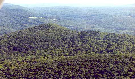
Minnechaug Mountain

Hampden, Massachusetts

The Minnechaug Mountain conservation land was acquired by the Town of Hampden.

The land was acquired in two stages: in 2001, 93 acres on the northeast slope, adjacent to 14 acres of town-owned conservation land, was purchased by the land trust (then known as “Hampden Land Project”) and turned over to the Town of Hampden; and in 2003, an abutting 166 acres on the northwest slope (including the peak) was protected as town-owned conservation land. These 273 acres are open to the public for passive recreation, and are enjoyed by hikers, birders, horseback riders, and the local Boy Scouts and Girl Scouts, who have been actively involved in trail work projects.

INTRODUCTION
Minnechaug Mountain, in Hampden, Massachusetts, is one of the finest hiking areas in and around the Pioneer Valley. The 908-foot mountain has three miles of marked trails as well as a variety of unmarked trails. Some of these trails link up with trails going south into Connecticut and north with trails going into Wilbraham. The Minnechaug Mountain Conservation area consists of 273 acres of protected land that was acquired through the efforts of the Hampden-Wilbraham Land Trust and is open to the public for non-motorized recreation. This area is under the management of the Hampden Conservation Commission.

THE TRAIL SYSTEM

Minnechaug Mountain has 8 well-marked trails that offer a variety of hiking experiences that will satisfy hikers and walkers at a variety of levels. There are several trails that meander through the woods without much change in altitude, and others that climb 500 vertical feet in a half-mile stretch. There are many loops of varying length so that backtracking is seldom necessary. Trials are marked with a standard trail-marking system. Marks consist of five-inch by two-inch vertical rectangles. Two marks together indicate a left or right turn. The elevated mark indicates the direction of the turn. Two marks, one on top of the other, indicate the end of a trail. Each trail is marked in its own color corresponding to the colors on the map. Trails are also labeled with wooden signs located at the various trail junctions. There are some nice views west and east from the Tennessee Valley Natural Gas pipeline that crosses the mountain near the summit. Many of the trails are suitable for cross-country skiing in the winter. The area is open to the public for non-motorized recreational activities. Motorized vehicles are not allowed as they result in a great deal of trail damage and erosion. Hunting is not allowed on conservation property.

TRAIL ACCESS
There are two main trail access points. The VFW on Main St, Hampden, allows parking. Hikers can cross the scenic Scantic River on the footbridge south of the parking area and access the Algonquin trail directly south of the bridge. The trail ascends steeply for a couple of hundred yards before it levels off and intersects the Old Coach Trail.
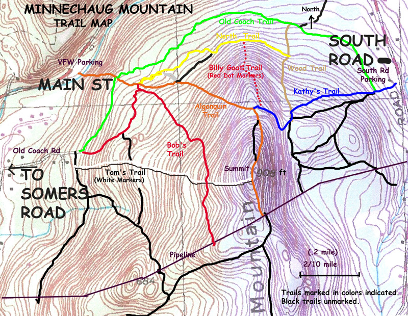
Maps will be available at the trail entrance.
The VFW parking is not available when they have Sunday Turkey Shoots, from 1:00 to 5:00 p.m. Check the VFW sign for exact dates.

The South Road parking area is about a mile from Main St on the right-hand side of the road and is marked by a sign. There is an information kiosk next to the parking area. Kathy’s Trail begins at the kiosk going south then north, bordering a field, before entering the woods. This is a more gradual access. The conservation area can also be assessed from Old Coach Rd. but currently there is no formal parking area.

THE TRAILS
Following is a brief description of each of the marked trails in the Minnechaug Mountain conservation area. They are shown on the map above.
Old Coach Trail
This is the longest and flattest trail in the system. Going east to west, it starts at Kathy’s trail near the South Rd parking area and ends at Old Coach Rd. Coming up Kathy’s trail from the parking area, take a left just after the stone wall. The green marked trail travels along the stone wall heading North before it turns east. There are many beautiful old stone walls in this area. Although off-road vehicles are not allowed in the conservation area, this trail has been damaged by extensive vehicle use. Parts of the trail have been re-routed to make for a more pleasant hiking experience. Just follow the green markers. One-quarter mile from Kathy’s trail, the trail meets the Wood trail on the left, then in one-half mile, intersects the Algonquin trail just south of the VFW parking area. The trail continues on and passes Bob’s trail on the left before ending just off The Old Coach Road cul-de-sac.
Bob’s Trail
This red marked trail is named after Bob Labodycz, who owned 166 acres of the land that is now part of the conservation area. This beautiful trail starts at Old Coach Rd., and climbs gradually for one-third of a mile before it intersects with North Trail and The Algonquin Trail. If you want to switch to one of these trails, follow the red markers to the left and then right. If you want to continue on Bob’s Trail, go straight. This trail has many twists and turns before it joins an old logging road going south toward the pipeline. The trail intersects Tom’s Trail in one-quarter mile, before it reaches the pipeline. Turn left and the pipeline and join up with the Algonquin Trail two-tenths of a mile from the summit. There are some nice views from the pipeline.
Tom’s Trail
This trail named after the late Tom Leary, who contributed greatly to the development of Rice’s Orchard conservation area in Wilbraham, and also began the initial planning of the Minnechaug hiking area, begins just South of Old Coach. Follow the old logging road for 100 yards, and look for the white marked trail on the left. This trail climbs steadily for about one-half mile and enters the Algonquin trail just South of the summit.
Algonquin Trail
This orange-marked trail developed by the Scouts many years ago ran from Perkins Mt in Somers, Ct over Rattlesnake Peak, Pine Mountain Bald Mountain, Around Minnechaug Mountain, crossed Main St at the VFW over Wilbraham Mt to Mount Vision and on into Wilbraham. Unfortunately, development has blocked some of the access points and parts of the trail. Presently the Algoquin trail starts at the VFW. The trail enters the woods just after you cross the Scantic River on the VFW foot bridge, and climbs very steeply for about 0.2 mile then crosses the Old Coach Trail, then shortly comes to the junction of North Trail and Bob’s trail. The trail winds through some interesting terrain before it joins up with an old logging road going left. A steady climb will bring you to the Southern end of Kathy’s trail. If you continue straight about 50 ft on the blue-marked Kathy’s Trail, you will see the entrance to the Billy Goat Trail on the Left. Turing right, the trail climbs steeply to the summit of Minnechaug Mt., crosses the summit ridge then ascends to the pipeline to the South.
Kathy’s Trail
This blue-marked trail is named after the late Kathy Ferriter who lived on the farm across from the South St. entrance. Kathy was an ardent and early supporter of preserving open space in Hampden. Memorial donations in her name made possible much of the financing for preliminary work. The trail starts at the South Rd. kiosk. Going south then east along the stone wall before entering the woods, along this section of trail one will see remnants of old farm equipment. Most of this area consists of woods that reclaimed fields cleared by early farmers in the area. Passing through a stone wall, the trail bends left for a short distance before taking a sharp right followed by a sharp left. The trail continues east climbing gently for 0.4 mile before joining the Wood trail entering from the right. Taking a sharp left, the trail proceeds through a hemlock grove before turning right and angling up the side of a steep grade. At the top of the ridge, the trail passes the Billy Goat Trail on the right, and then ends as it meets the Algonquin Trail.
Wood Trail
This trail named after Lyman and Merrie Wood, generous benefactors to the Hampden Land Project, begins at the Old Coach Trail and climbs gradually to Kathy’s Trail. Following tan markers, this trail passes the eastern entrance of the North Trail on the right as you ascend toward Kathy’s Trail. This trail makes it possible to hike various loops using different trails.
North Trail
The yellow-marked North trail is relatively flat as it starts at the Algonquin trail and travels east through some young forest before turning sharply south though fern beds alongside a drainage area. The trail then turns left on a logging road, before winding back into the woods on the way to Wood Trail. At about 0.4 of a mile the red-circle Billy Goat Trail will ascend steeply on the right.
Billy Goat Trail
This short but steep trail, marked with red circles ascends the northern ridge of Minnechaug Mt. This trail is great for those who like to gain lots of altitude in a short distance. In late fall and winter, there are some good views of the Scantic Valley. The trail ends at the top of the ridge as it runs into Kathy’s Trail.